Course Details
Mt Buller Village—Mt Stirling—Craig’s Hut—Delatite River—Mt Buller Summit—Mt Buller Village
Stage 1
Mt Buller Village—Howqua Gap—4.6 km
- From the Village square, follow the marked course to the Circuit Road.
- Cross the Circuit Road and pick up the trail signposted “7” and follow this to a track junction.
- Follow the track marked “Stirling via Corn Hill” (a 4WD track).
- Follow the Corn Hill fire trail (do not go to the summit) before dropping down to Howqua Gap.
Stage 2
Howqua Gap—Mt Stirling—4.0 km
- Cross the Circuit Rd and take the foot path up to Howqua Gap Hut (toilet/water).
- Follow the Howqua Gap track past Maps 47, 48, 45 and 40 up to Stanley’s Bowl and then onto the summit of Mt Stirling (1749 m)—great views! There is a checkpoint here with water, chips, fruit, sweets and first aid.
Caution—be aware of 4WDs on the track.
Stage 3
Mt Stirling Summit—Craig’s Hut return—8.8 km
- From the summit return to the 4WD track.
- Turn left and follow the road about 100 m until a junction.
- Turn half right and follow the Clear Hills Trail (Map 38).
- Continue downhill past Map 49 to Craig’s Hut.
- At the cleared “Y” intersection turn left to Craig’s Hut (toilet/water).
- Take a few minutes to take in the hut and the great views.
- Return to Mt Stirling via the same route.
Stage 4
Mt Stirling—Mirimbah—15.1 km
- From Mt Stirling retrace your route until you get to River Spur Trail (Map 45) turn right and proceed down the ridge.
- Go through a gate and cross the Circuit Road (look for traffic) and through another gate.
- Continue downhill until you get to the first bridge across the Delatite.
- Cross the Delatite river on the log bridge and turn right.
- Follow the river, crossing it 14 times on log bridges to Mirimbah Park. There are toilets before reaching the checkpoint here. The checkpoint has water, chips, fruit, sweets and first aid.
Stage 5
Mirimbah—Mt Buller Summit—Village Square—approx 12.3 km
NB: There is a 1 P.M. cut off at Mirimbah Park and a 3 P.M. cut off at Northside Express.
- Cross the road with caution and then at the car park (elevation 690 m) follow the Klingsporn trail up to Mount Buller Summit.
- Take in the history at “Thank Christ Corner” (4.5 km)
- Continue up to the ski area and at the junction of Burnt Hut Road and the Klingsporn Track.
- Follow the Burnt Hut Road until it joins the Summit Nature Walk to the Summit Car Park.
- At the car park take the trail to the fire tower on top of Mt Buller 1805 m (great views).
- Descend back to the Summit Car Park and turn right onto the Nature Walk to finish back at the village square.
Caution—be aware of side trails used by very fast downhill mountain bikers.
Elevation Profile

To download the JPEG file, click here.
Maps
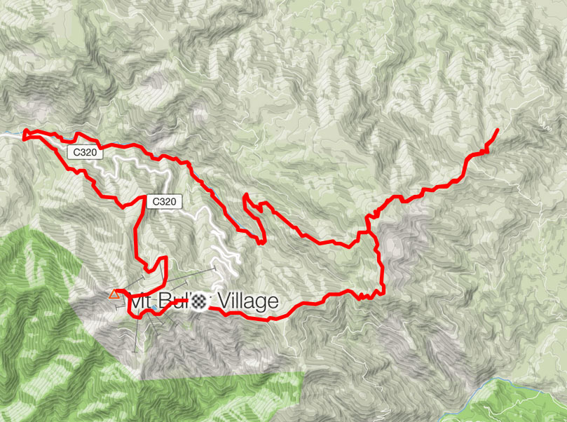
Map, elevation profile and Strava activity by courtesy of Tom Brazier https://www.strava.com/activities/275679128

To download the pdf, click here and to download the GPX click here.